Trip to Honey Island Swamp


On our third day in New Orleans, we headed to Slidell, LA, to visit the swamp.  Many swamp tours exist in the area and some in Lafayette as well.  After reading extensively online about the various tours, I decided to take Dr. Wagner’s Honey Island tour early in the morning.  Depending on traffic, it is about a 3/4 to one hour drive from downtown New Orleans.  For at least half this time, you are driving on a bridge across Lake Pontchartrain.

IMG_2773

This little swampy area is right next to the small cabin where they sell alligator souvenirs and you pick up your ticket.  This place requires cash.

IMG_2747

After boarding the boat which holds about 20 passengers, we headed down the Pearl River.  This view looks upriver.

IMG_2748

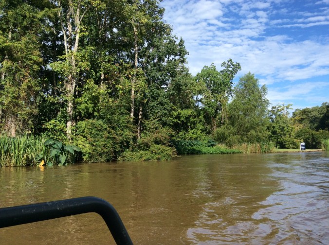
Many expensive houses rise above the river banks.  You can see the for sale sign.  According to the boat captain, the fancier ones cost about one million.  However, for all the elegant houses, there are more just the opposite and close by.

IMG_2750

Like this one which appears boarded up.  Some appeared abandoned, some in decent repair, some recently used.  When we asked how high the water rose during Katrina, we were told that it would be above the roof of a house like this.  The tours were abandoned for over a year after the hurricane except for the occasional hurricane cleanup crew who wanted a tour.

IMG_2749

This is one of the nice houses along the river, modern, large, well kept.

IMG_2751

We saw a large blue heron, wings outstretched, sunning itself on a large tree stump.  When the captain tried to get closer, it slowly lifted off and flew away before I could get a photo.

IMG_2757

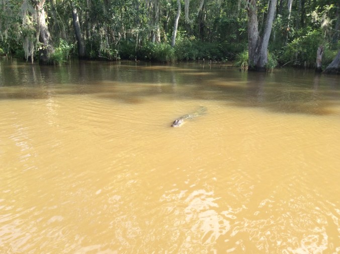
We turned to the right off the river and began to see alligators of all sizes.  Because of harvesting for skins, meat, etc., few really large ones remain.  More common is 8-10 footers.

IMG_2762

Even the boat captain was astonished at the number of alligators we saw.  They seemed to be everywhere and one exceedingly large male followed us deeper into the swamp.

IMG_2764

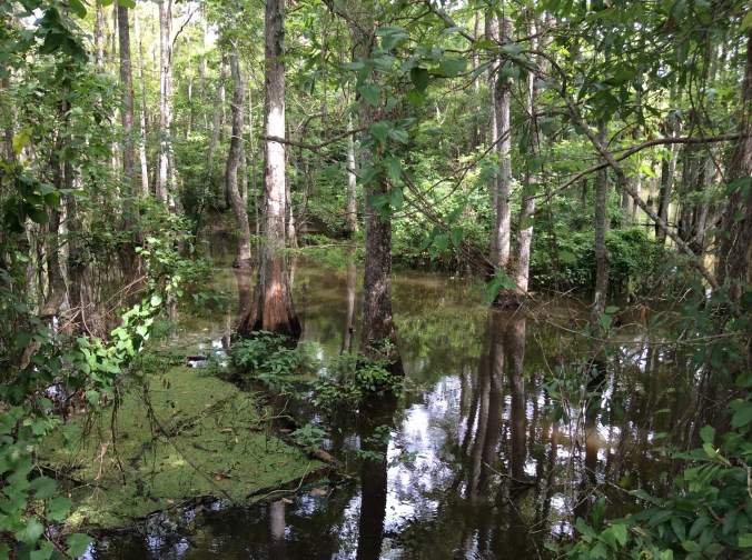
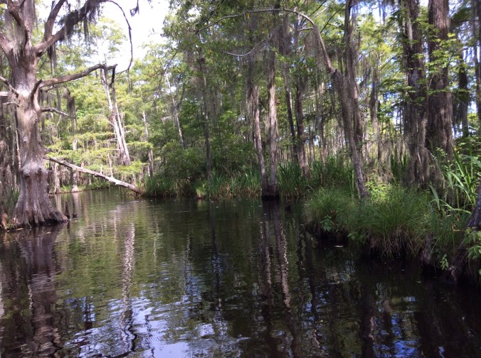
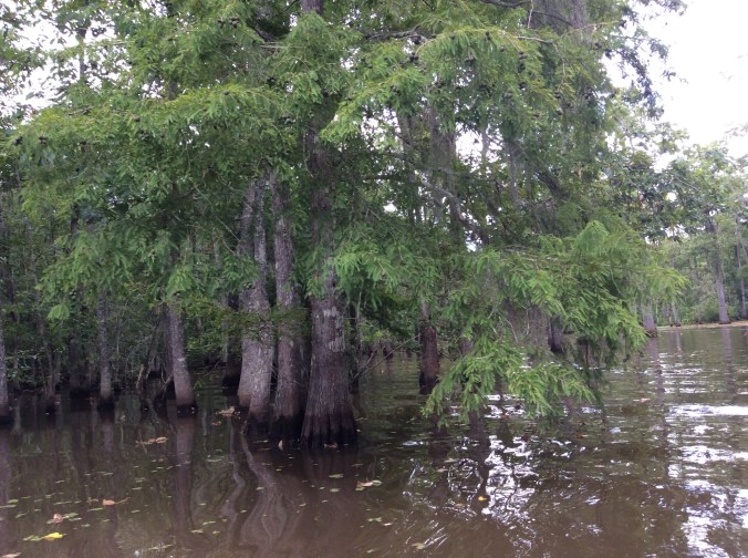
Although the water flows rather rapidly on the river, once in the swamp, the water is very quiet.  Many different types of trees live here including cypress.  Most of the trees are deciduous and lose their leaves in the winter.  I was extremely surprised to learn how cold it can get here, below freezing, sometimes even down in the teens.  However, the captain said it always rises above freezing during the day.

IMG_2765

IMG_2766

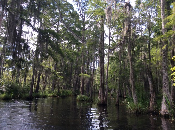
Most of the really large cypress have been cut down in the past for lumber.  Now this is a reserve.  The tree on the left is really large and a lot of moss hangs from it.

IMG_2767

Hogs, like these, are not native anywhere in the Western Hemisphere.  It seems feral hogs can live anywhere.  We also saw raccoons.  The trees and other vegetation are so dense during the summer, wildlife could be a few feet away and remain unseen.

IMG_2769

IMG_2772

The swamp possesses a wild, magical beauty.


Star Tree – Star Goddess by Judith Shaw


See the paintings. With deforestation affecting so much of the world, the idea of trees as sacred is especially appealing and meaningful.

Judith Shaw's avatarFeminism and Religion

judith shaw photo

In a world where humans were small and nature was big, surrounded by forests of trees of immense size and stature, it’s not surprising that the ancient Celts came to hold trees as sacred. Like many others, the Celts revered the World Tree or the Tree of Life as the mythic bridge between heaven and earth. The roots reach down and ground with the Earth while the branches spread their canopy up to the heavens.

View original post 745 more words

Grateful


Six days ago a huge storm struck, including eight inches of hail, a rain deluge, and high winds.  While the hail denuded many plants and bushes, the deluge made my drive a mess.

IMG_2711

Although it may be hard to determine the depth of the gravel and dirt and rocks from this photo, many of the rocks are bigger than the size of the fists of both my hands together, large enough to not want car tires to drive over them.  The gravel and dirt on the far side of the photo were at least eight inches deep.  Luckily I have a small tractor with a bucket and a helpful grandson.  He picked up the larger rocks and hauled all of them to the ditch created either side of the steep incline above the cement.  The rain had created a trench a foot deep in some places and exposed a pipe to the septic system. He filled parts of these trenches with the bigger rocks.

The next morning I used the tractor bucket to scoop up dirt and rocks and haul them to washed out places in the upper drive.  It was impossible to get it all with the bucket given some of the space is not very big or where it was possible to maneuver the tractor.  Therefore, I had to scoop it up and remove it with a shovel.  It took several tractor buckets full to get rid of what I had to shovel.  Finally, this morning I finished sweeping the rest of the fine sandstone off the cement.

After all this, why am I grateful?  There was no damage to my house.  The hail broke windows in some houses not far away, the wind blew light weight buildings into neighbors’ yards, and some people nearby had roof damage. I only have some tiny damage to the barn roof.  It could have been a lot worse.  I feel grateful to have escaped with just a messed up driveway.

Why do I feel even more grateful?  It occurred to me that I was able to clean up most of this except for my grandson’s help with the rocks–which I could have done but it was helpful.  I can still shovel gravel and dirt, a lot of it, lift and carry 50 pounds of horse feed from the vehicle across the barn–about 40 ft or more–and dump it in the container. I can work for hours doing this sort of stuff and feel fine afterwards. Yes, I feel grateful that I can continue to do all these things myself and what is more, usually enjoy doing them, feeling productive and independent.

When people ask me how I do all this, I usually tell them two things, yoga (as well as lots of other exercise mandatory if you live in the country and have animals) and heathy food.  My yoga practice began decades ago; I never stopped.  I practice it at least three times a week, sometimes more.  I stand on my head in the middle of the room several times a week.  My favorite foods are mostly vegetables.  The only carb I really like is rice. One of my dad’s sayings was, “You are what you eat.”  He still ran a farm at 90.  Yes, I admit, genes probably help, but without the exercise and self discipline, it probably is not enough.  I also meditate daily which does not require lots of time unless you want to spend lots of time doing it.  Even 15-30 minutes a day matter.  Exercise, yoga, healthy eating, meditating will all make for a happier person.  I promise.


Spring Break Adventure–4


Today was the second day at Big Bend.  We spent most of the day in the Chisos Basin where the park lodge is located.  The four of us started the hike all the way to the “window” and two of us finished it, which enabled me to not only experience a hike full of wonder but also to get over 20000 on my Fitbit for the day.  I also have a sunburn now.  For this post I will just add photos with little comment.  Later I will add more details about this astonishing place.

imageimage

image

image

Although I took some of these photos, I did not take anything on the hike so thanks to a friend you are seeing some of these.  This is bear and mountain lion country so there are signs telling you what to do if you see one, hardly likely with so many people around.  However, all the campsites have metal containers in which to lock food from bears.

Spring Break Adventure–2


Today we went to MacDonald Observatory and signed up for a tour.  It was more than we imagined.

The views 360 degrees since you are at the top are, well, spectacular.

In the distance a cloud bank hung over the mountains.

I stood back to take a photo of the different buildings that house the actual telescopes.

We entered the building on the right which houses the 107 inch telescope and walked up 77 stair steps to see it.


image

image

It is too large to get a photo of the entire telescope.  Depending on what the astronomers want to study, different parts are added and subtracted.  The room is temperature controlled between 40 and 50 degrees. The photo below shows another area with a different type of telescope currently under construction.

image

After leaving here, we took a scenic drive in a circle through the mountains.

We were especially impressed with the unusual rock formations and the giant cotton wood trees of which we saw dozens along a stream bed.

Another bill aims to take wolves off endangered list


For a number of years I have mulled over reasons why humans seem to hate wolves considerable more than other predators. I have my own “theories”. What are yours?

Wolf is my Soul's avatarWolf Is My Soul

January 10, 2017

A gray wolf moves through forested country in winter. Credit: MacNeil Lyons, National Park Service

The new Congress wasted little time in efforts to once again remove gray wolves from the federal endangered species list.

A bill introduced Tuesday by U.S. Reps. Collin Peterson, D-Minnesota; Sean Duffy, R-Wisconsin; and Liz Cheney, R-Wyoming, would overrule a federal court action and remove federal protections from wolves in the Great Lakes and mountain west.

That already happened once, but a judge’s decision in late 2014 restored federal protections after wolves spent about three years under state control.

The members of Congress, and the U.S. Fish and Wildlife Service, say wolves have recovered enough in those areas to remove protections. But wolf supporters say the wolf hasn’t recovered over enough of its original range to remove protections in the few states where it is thriving, like Minnesota and Wisconsin. Wolf supporters…

View original post 129 more words

Hiking Palo Duro Canyon State Park–Day Two, New Year’s Day


In spite of having to run/rush, I enjoyed the first hike so much, I decided to go back down with my son on New Year’s Day, another weather perfect hiking and biking day.  I hiked the same trail but had time to enjoy it, take more photos.

img_2411-1

I headed up Comanche Trail from Chinaberry area toward the same peak in the distance.  Although this trail is not difficult, it is not flat until you get to the bottom of the cliffs in the distance.

img_2423

At this point I have reached the same area where I took most of the rock photos on the first Palo Duro post.  Once again, I took off onto the “new” trail to the north.

img_2432

To get to this point one has to climb down a rather steep trail and cross a dry arroyo and start up the other side.  This is across from where I had previously seen the shovels, etc.  They were still there, but the other equipment had been moved to just below where I took this photo.

This trail contains a lot of loose debris and dirt with large boulders laying every which way.

img_2436

Once I reached the flat top area, I saw those orange/red flags here and there and now wonder where the trail will eventually go.  I headed back toward Comanche.

img_2445

Back near Comanche Trail.

img_2447

At this point I had walked far enough down Comanche to be slightly past the cliff toward which I was originally headed.

img_2449

If you look in the middle distance, you can see the road in and out of the park.  Here I have walked considerably past the peak seen in the first photo.

img_2450

All kinds of rocks of all sizes appear everywhere–layers and layers of time.

img_2452

The trail follows the base of miles of cliffs.

img_2453

Fallen rocks and “caves” everywhere.

img_2454

Looking back from where I had climbed up higher and higher toward the flatter area.

img_2458

Another smaller “cave”.  I seriously considered hiking to it, figuring there might be some rattlesnakes sunning.  They do not react a lot unless startled or out hunting.

img_2459

Along the cliff base where the trail is easy.

img_2460

In this area, huge, white boulders appear to have fallen from the whiter area in the cliffs above.

img_2461

Farther down these boulders appear, more porous, darker.

img_2462

A closeup of this boulder shows baby prickly pear and grass growing from its surface.

img_2463

Farther south along the trail looking north.

img_2464

There are many species of prickly pear, including this one with its bright color.

img_2465

I looked up and saw three aoudad sheep.  See if you can find any of them in the middle of the photo.  They really blend in with these rocks.

img_2466

I did walk a bit off the trail to take this photo of “coffin” rock.

img_2467

Past the flat area canyon colors show up really brightly here–layers of color and time everywhere.

img_2468

Farther along the trail, looking toward the south.

img_2473

At this point on the trail past the long cliff wall, the trail becomes steeper and up and down again.

img_2474

Farther and farther past the cliff wall.

img_2475

Then one comes down farther where a small, spring fed stream runs.

img_2480

Here with year round water and shade the trees grow much bigger.  Farther down the trail more water seeps and the trail above contains steeper switch backs.

img_2481

img_2482

Far past the cliff base, Comanche intersects Rock Garden Trail.  Once again, but not running/rushing this time, I start down Rock Garden.

img_2483

Looking south, I headed down.  Rock Garden gets its name from an ancient rock slide.

img_2485

Giant boulders everywhere.

img_2486

Some even have grass growing from them.

img_2488

I wanted to take a photo of this boulder because it looks like a giant face with ears.  However, it was so late that I could not take it without my shadow so being silly…

img_2489

Almost down, I took one final photo.  Comanche is the longest trail in the park.  It keeps going past the Rock Garden intersection.  My son, who was mountain biking there a couple of days later, rode almost its entire length.  Some day I want to start at Chinaberry and walk to the end.  However, if you plan to do this, find someone to meet you at the south (far) end because otherwise you will have miles to hike back.