If you ever read “The Adventures of Huckleberry Finn” by Mark Twain, then you already know the characters in this new novel. If you have not read about Huck, then I suggest you might want to read Cliff Notes or some other synopsis of Twain’s novel. “James” takes its title from the name of one of the main characters, a slave who lives in Hannibal, Missouri. He is generally called Jim, but in reality prefers the more formal James. Basically, Everett’s novel is written from the viewpoint of James, e.g Jim. Most of the major events in Twain’s original novel are followed in this novel, but from James’ viewpoint. Huck, a poor kid, runs away to avoid his violent father and finds James hiding out on an island in the Mississippi River. Together they live off the land, float in their handmade raft down the Mississippi River, mostly at night to avoid anyone seeing them, and meet all sorts of folks, including two men, who are criminals pretending to be European royalty. It is hard to imagine how a novel about the horrors of slavery could possess any humor, but this one does. It is a quick, enlightening, and entertaining read filled with “lessons” that do not seem to be lessons because they are so intertwined with the James’ story.
This memoir tells the tale of an unusual tour for a specific purpose, to follow the path of Mennonites who left Europe to escape conscription into the army since the Mennonites are pacifists. The author’s own life is unusual. Her mother was a Swiss Mennonite missionary to Somalia. Her Muslim Somali father taught the Mennonite missionaries Swahili. The two met and married. Samatar grew up and lives as a Mennonite. She teaches African and Arabic literature at James Madison Un. She is most famous for her fantasy novels and short stories which is how I discovered her writing.
In the late 19th century a group of German speaking Mennonites left Russia for Central Asia where their leader believed Christ would return. They suffered many hardships, rejection, abuse, but finally found a place that welcomed them in the Muslim Khanate of Khiva in what is now Uzbekistan. There they built a white church which the locals called Ak Metchet, the White Mosque. Their village lasted 50 years.
If you go online, you can find tours today that follow the route of these Mennonite travelers, trace their route. This book details Samatar’s experiences on the tour, the tour guides, the food, the architecture, the culture and the history: a 15th century astronomer king, the first Uzbek photographer, Mennonite martyrs. She also discusses her own unique upbringing, local beliefs and culture, how people develop their own personal identity, and the surprising interconnections people sometimes discover.
A tale based on a Bengali legend about a merchant called the Gun Merchant, Bonduki Sadagar, this novel not only takes place in the mangrove swamps of the Sundarbans but also in Venice. It has nothing to do with guns but demonstrates how differences in language use among languages and translations can lead to total mistranslation. The narrator is an older, male, Bengali, rare book dealer who grew up in Kolkata but now lives in Brooklyn most of the year and goes back “home” occasionally. When he meets a distant relative by chance at a party, he finds himself enmeshed in the Gun Merchant tale and finds himself in search of a remote shrine where a king cobra lives. His adventure leads him to meet two young men and reconnect with an old friend, an Italian woman who is a famous historian.
What fascinated me most about this novel was learning all about the immense number of historical connections between the Bengali part of India and Venice especially related to trade and persons of Jewish descent. It is also filled with lessons in relationships among languages and history. For example, I learned the origin of the word ghetto. During the 17th century a part of Venice, Getto, was where their large and prosperous Jewish population was forced to live, Venice being one of few European cities where Jews were safe. Thus the word designating a part of the city became the word ghetto.
It is also a story about the risks and dangers of immigrants trying to get to Europe. I learned many Bengalis, mostly from Bangladesh, live in Venice and the numerous historical connections between the Bengali speaking areas of the world and Venice.
While I found her first book, “The Tiger’s Wife” fascinating, I remain uncertain regarding this one. First it is long, 374 pages (I do read long books); second, it tells two different stories which do not interconnect at all until the end of the book. I kept wondering, asking myself, “What?” For me at least, the story picked up about half way through and my interest greatly increased.
One storyline is the life of one homesteading family in rural Arizona in the 1850s told mostly from the viewpoint of the wife. Her husband tends to wander off for long periods of time leaving her on her own with their children. His latest adventure is not only their homestead but also owning and running the local newspaper in the nearest town. The reader also meets some rather powerful but unsavory characters who want to own all the cattle and all the land.
The second storyline deals with the men who were hired by the government to bring camels to the West and manage them, one of whose story–a real historical person–is told. His name was Ali, a Syrian cameleer, who died in 1902. He was called Hi Jolly because people in US seemed unable or unwilling to pronounce his real name correctly. This part is told from the viewpoint of another cameleer, Hi Jolly’s friend, who has a criminal history and is trying to elude the law. Camels were brought to the US by the United States Camel Corps in the 1850s. At that time few roads existed in the Southwest, water was scarce, and camels were known to be able to go long periods without water. The experiment failed so camels were left either in the hands of the individuals who rode and cared for them or left to roam wild. Some of the men, including Hi Jolly, were able to open businesses transporting goods to remote areas via camel. This book details part of that history.
In both storylines one recurring theme is the lack of water. At one point the homesteading family have no water at all. In the other storyline people hire the cameleers to take them to places not realizing that even camels need water occasionally. I find it telling that 175 years later we continue to struggle with water issues in exactly the same part of the country.
Arcosanti, an innovative village 70 miles north of Phoenix in the high desert, houses between 80-100 people who currently live there full-time. To become a resident, a person has to apply, take a five week course, and be able to contribute to the community. Their major business is making bronze bells in their foundry. They also host conventions. The week before I arrived, they hosted a convention of the executives of a corporation.
A few rooms of varying sizes are available to rent. They are pleasant with a view and modern amenities but not luxurious in the way some top hotels are. Here are views from my room.
After I arrived and unpacked, I took a walk up the hill and around the buildings.
This is a sort of giant classroom where it appeared they had been teaching how to make ceramics. The buildings are unique with the concept to fit in with the surroundings and take as little energy and resources from nature as possible.
This is the other side of the building in the previous photo. It is very hilly here and the buildings are build on the side of a steep hill.
The same building from a different angle. It was very windy when I was there and part of the area was closed due to the wind. There are bells everywhere and all were ringing in varying musical tones.
I walked down the road from my room, on a long trail, and up a steep incline to arrive across from the buildings so I could take these photos.
A closer view from across the arroyo.
This is across the arroyo from the main buildings. In the shadow, there is a door. I never learned what all this is for or what might exist behind the door.
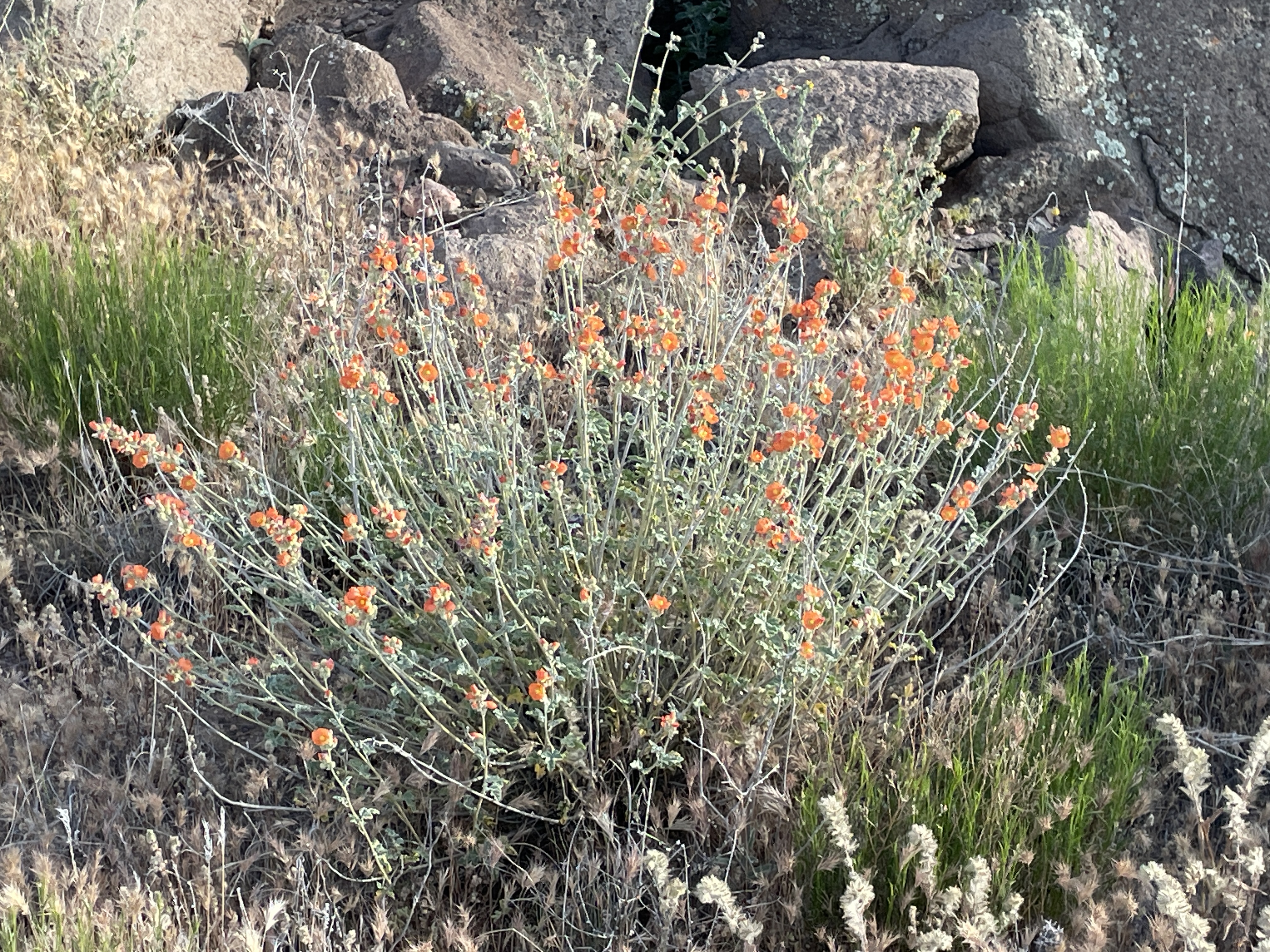
All sorts of wildflowers were blooming when I was there in May.
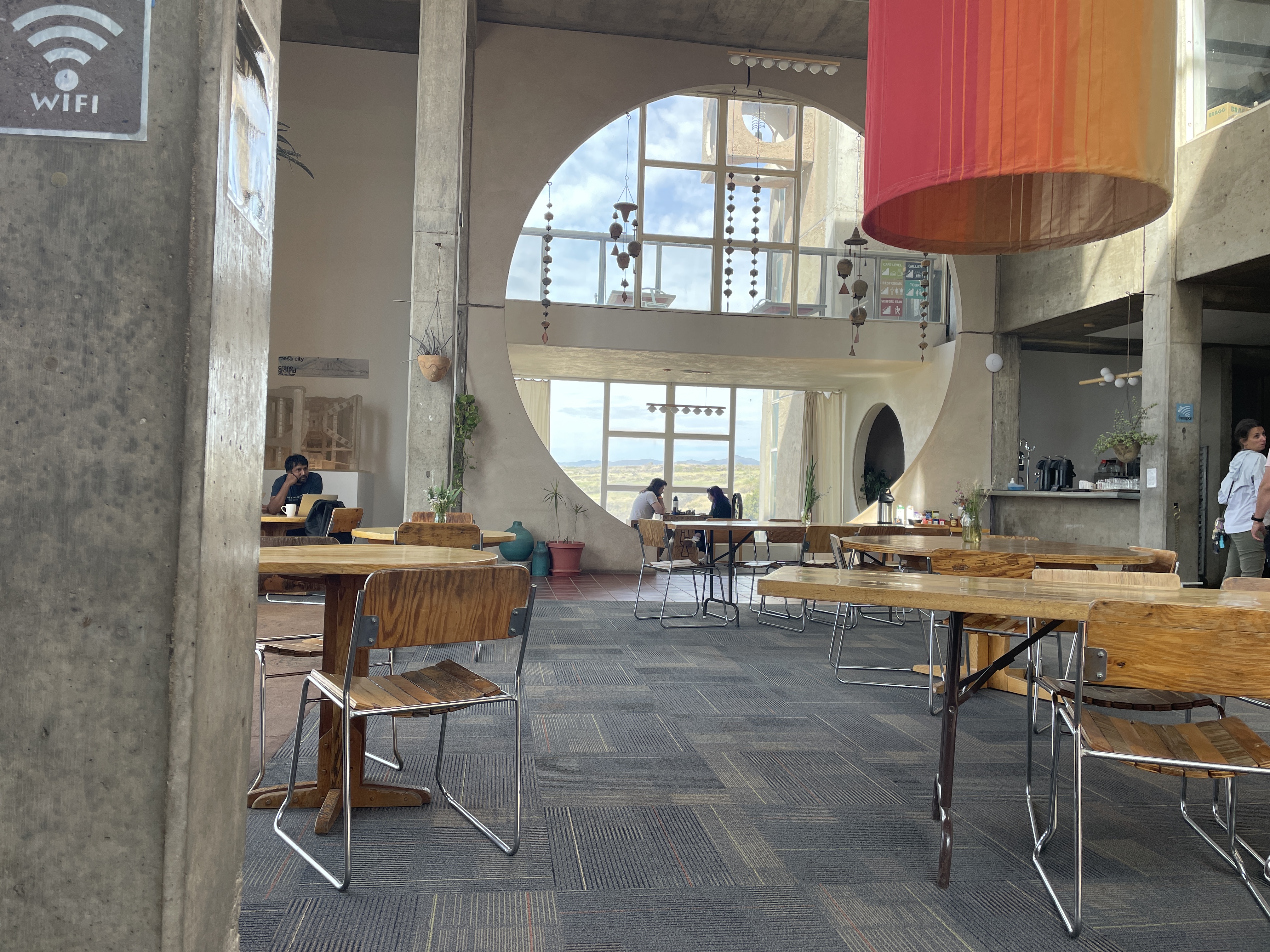
The restaurant is unique and delightful. They serve excellent coffee–one day some was lavender infused–and various other simple dishes and pastries they make on site. The orange column you see is installed in winter to provide natural heating using natural airflow and taken down in late spring. This is a unique and pleasant place to visit. You can take tours. If you stay there, you can wander around freely. And, of course, you can purchase bells from the very small to some that are quite large and like metal works of art.
Several weeks ago, I spent a day wandering around the ancient sites where native peoples gathered over a thousand years ago.
This explains the extensive influence this place, located in the northwestern New Mexico desert, held for people from as far away as Central America. To reach this park, you have to drive on a dirt/gravel, rough road for more than 25 miles north of Crownpoint, NM. It is definitely worth the effort. However, it is impassable in rainy or snowy weather. The rangers who care for the park live there.
One of the first things you see as you get closer to the park is this rock tower, Fajada Butte.
Archeologists climbed to the top and discovered petroglyphs, “Sun Daggers”. Created between rock slabs, they align with each solstice and equinox and at these events the light projects to other sites, e.g. Pueblo Bonito. Other petroglyphs on a section of the canyon wall represent a supernova that occurred in 1054 CE.
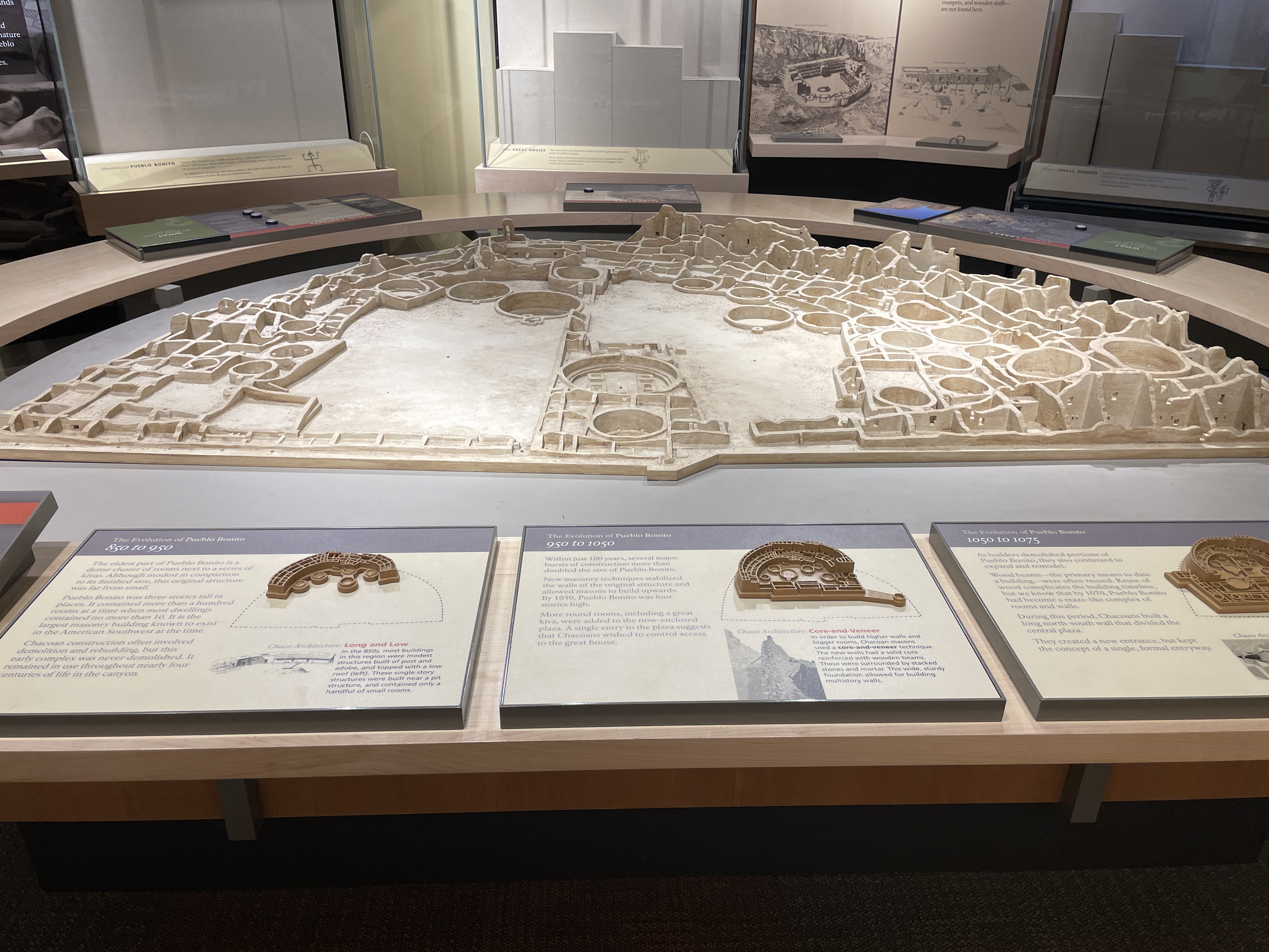
The following depicts an overview of the site as it would have been in the past. In the 1940s part of the wall of rock behind the site collapsed onto it and destroyed some of the buildings.
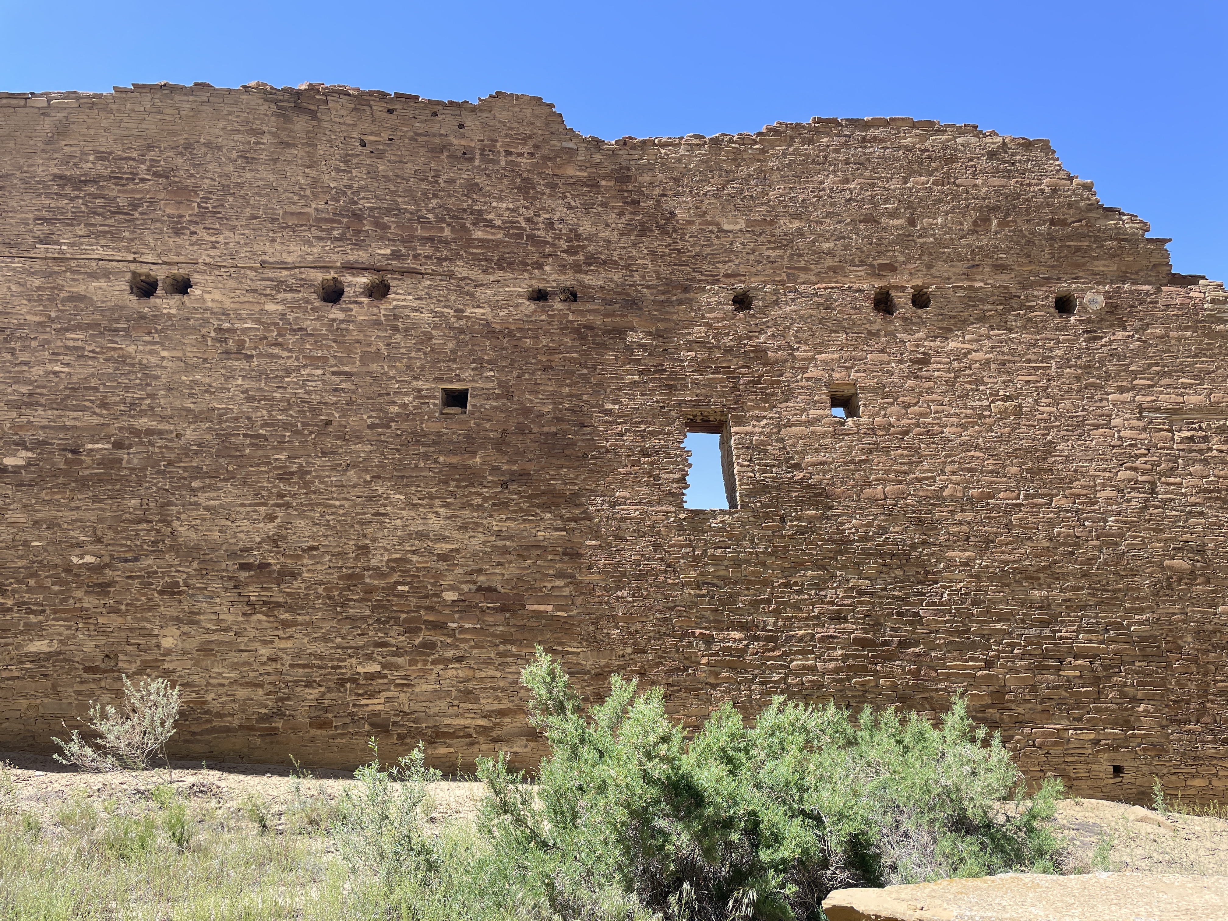
Here is how it looks today. Many of the doors and windows align with astronomical events, e.g. solstices, the two equinox, and astronomical events that occur only every 17 years.
All sites here contain many kivas, many of which are very large. It is speculated that these were used for various sorts of ceremonies, including religious events.
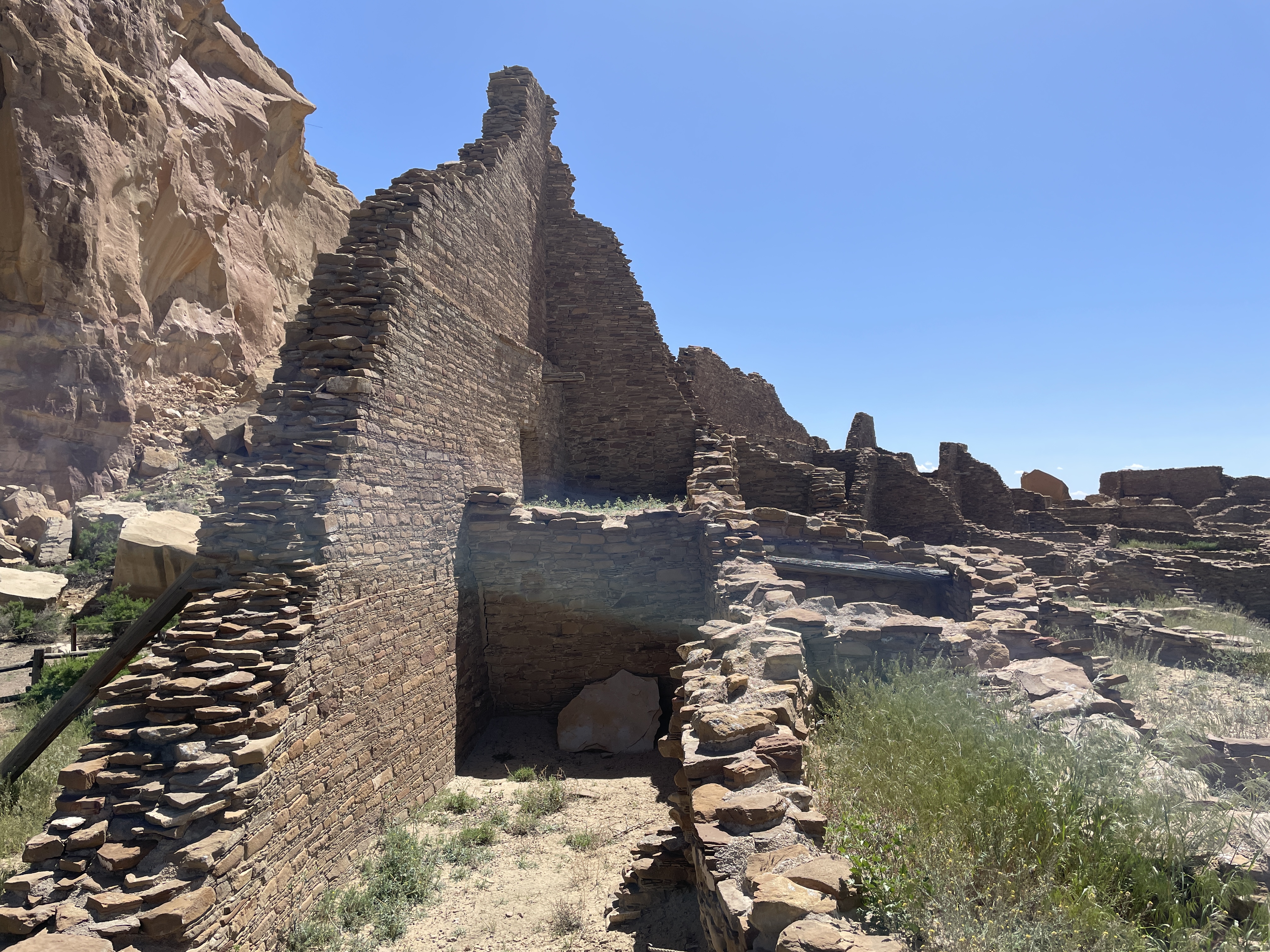
In this view you can see how the rocks that fell from the cliff have destroyed parts of the structures.
Many of the buildings were several stories high. In their heyday, they did not look like this. They were covered with something like stucco and painted white. What an impressive site they must have been–large white structures in the middle of the brown desert. Archeologists think few people lived here. It was a place for gathering, for ceremonies, for trade, for people from long distances to meet.
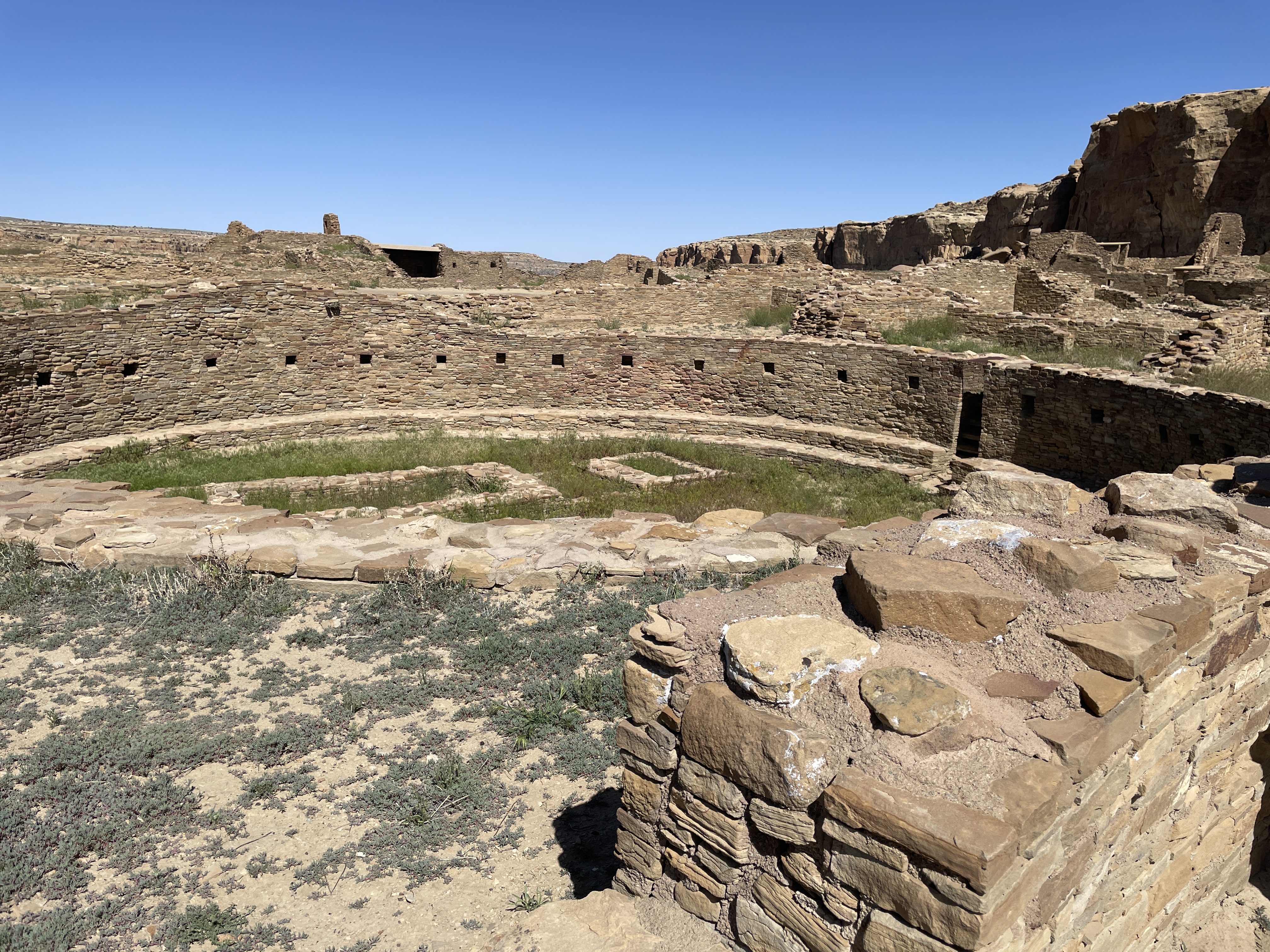
Across from Pueblo Bonito is the largest kiva found in the area.
Behind the bars on the far side of the photo is an area that was used for ceremonial dancers to don their costumes. At the bottom you can see a depression with a small door. Before centuries of sand filled it in, this place would have be large enough for the ceremonial dancers to enter through it.
If you follow a trail along the cliff from Pueblo Bonito, you will find another area built at different times hundreds of years ago.
Another large kiva and many smaller ones are located at this site, including this famous long wall built at two different times.
The following shows where at some point the wall stopped, then later it was continued using somewhat different building material and techniques.
The top photo is considered the newer part of the wall.
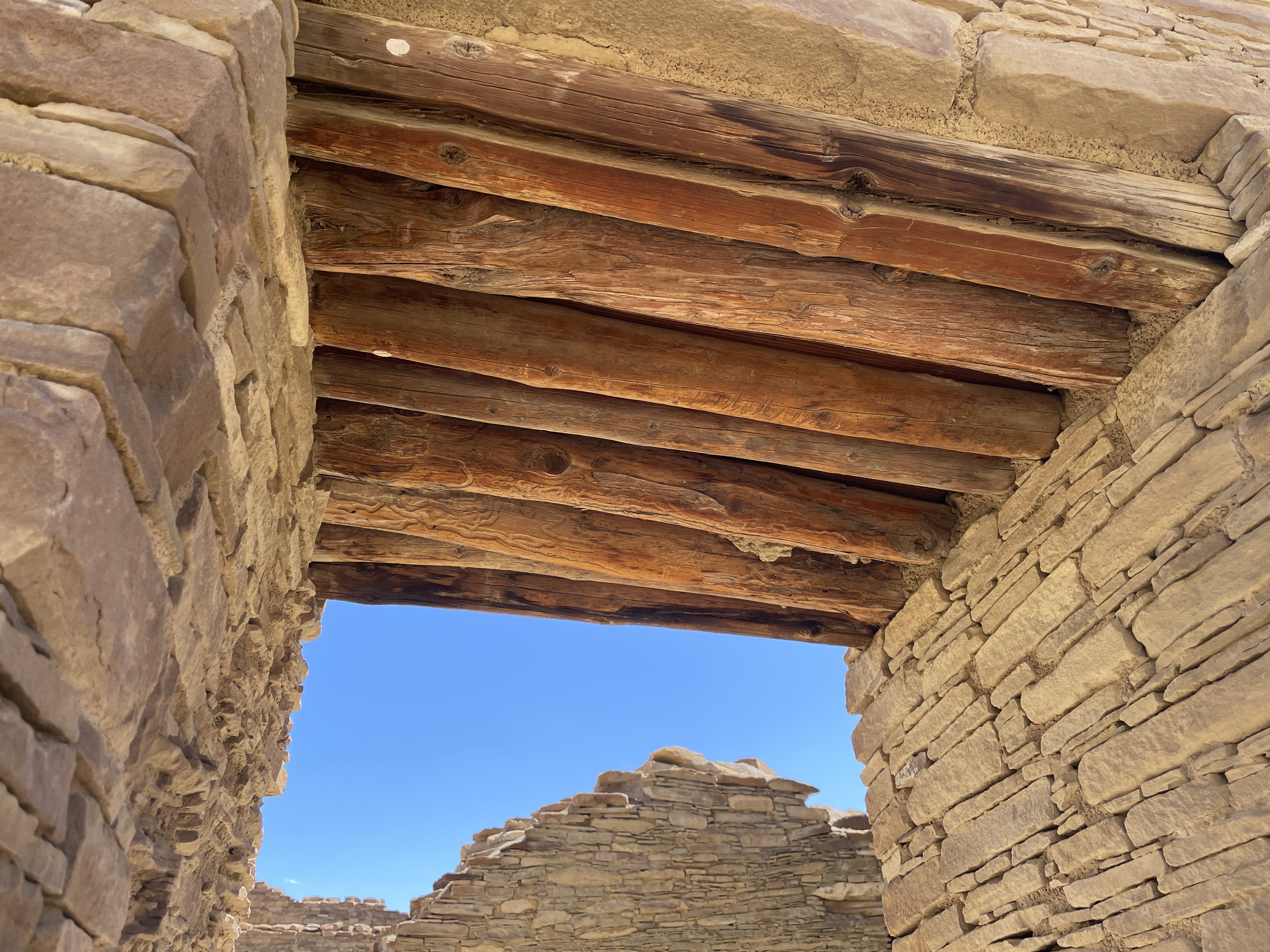
The wood used for tops of windows and doors was brought from forests hundreds of miles away. The desert air has enable it to be preserved.
When you walk the trails, you see wild flowers and native plants. This is desert rhubarb and it is edible.
While these are photos of the more impressive structures at Chaco Canyon, more than two hundred ceremonial and meeting sites can be found in this area of NM and AZ.
If you like the unusual, violence, magic, revenge, stories of racism, classism, and Westerns, this is the book for you. Ming Tsu, a Chinese orphan at the time when the Chinese were building the railroad, is taken in by the head of a crime organization and taught to be an assassin. He falls in love with Ada, the daughter of a wealthy railroad magnate, elopes with her only to have her father (who has hired the crime organization to further his goals) kidnap her and force Ming Tsu into labor for the railroad. He eventually escapes, joins with a Chinese clairvoyant whom he calls the Prophet and a group of touring magic show performers, many of whom have supernatural abilities. He sets out to gain revenge, hunting down and killing all who helped his father-in-law kidnap Ada and put him in bondage. This is the classic Western romance, revenge story with a totally different twist and an unexpected ending.
Canyon de Chelley was named by the Spanish who could not quite pronounce the Diné (Navaho) word for it and hence this name which is pronounced like de shay. It is more than 30 miles long and has a river running through it at least a substantial part of the year. In summer native people live there with sheep, horses, etc. even though fewer and fewer of the younger generation choose to do so. To enter the bottom of the canyon, you must acquire a permit and hire a Navaho driver. This is to protect it from the vandalism that occurred in the past. Canyon de Chelley is jointly managed by the National Park Service and the Navaho Nation.
Canyon de Chelley begins at the edge of Chinle, AZ, near the Holiday Inn which, by the way, serves traditional food such as mutton stew and blue corn fry bread. Yes, I ate both. This photo shows the beginning.
It was quite a trip; I sat between two women in the back of a Jeep with a perfect view of everything right in front of me. Oscar, the driver, knew exactly how to traverse the water, the wash (what they call this stream), run up and down the banks.
Driving right up the middle of the wash.
Petroglyphs can be seen in so many places we stopped that I lost count. Oscar said they are nearly endless and can be found throughout the canyon walls.
A few days previous to our arrival it had snowed so everything was green and lush from snow melt.
In addition to petroglyphs, there are etchings in the rock walls.
In this case an etching/rock carving of horses.
Yes, we drove under this overhanging tree limb.
Sometimes the wash was narrower and deeper and we drove up and down steep banks and through deeper water.
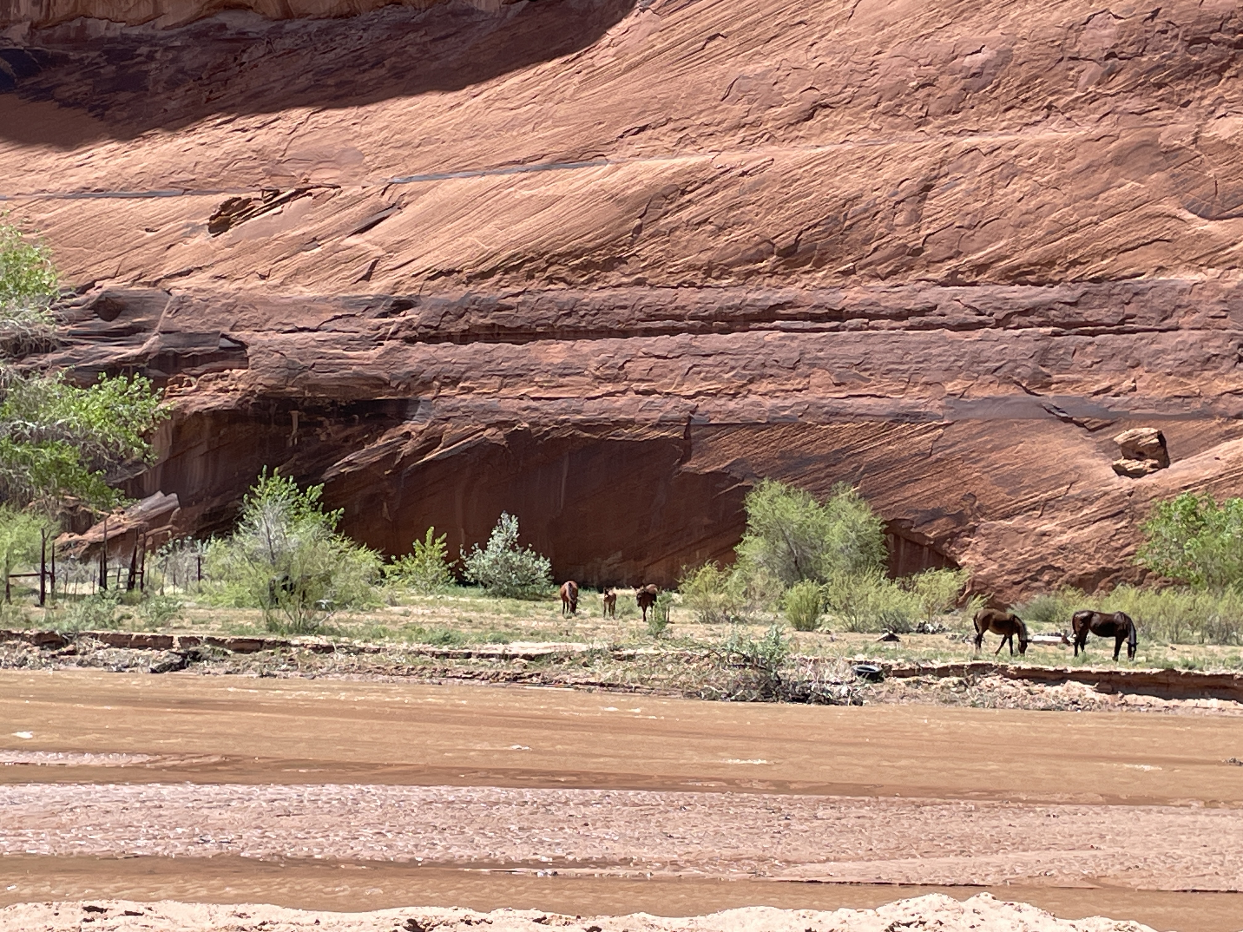
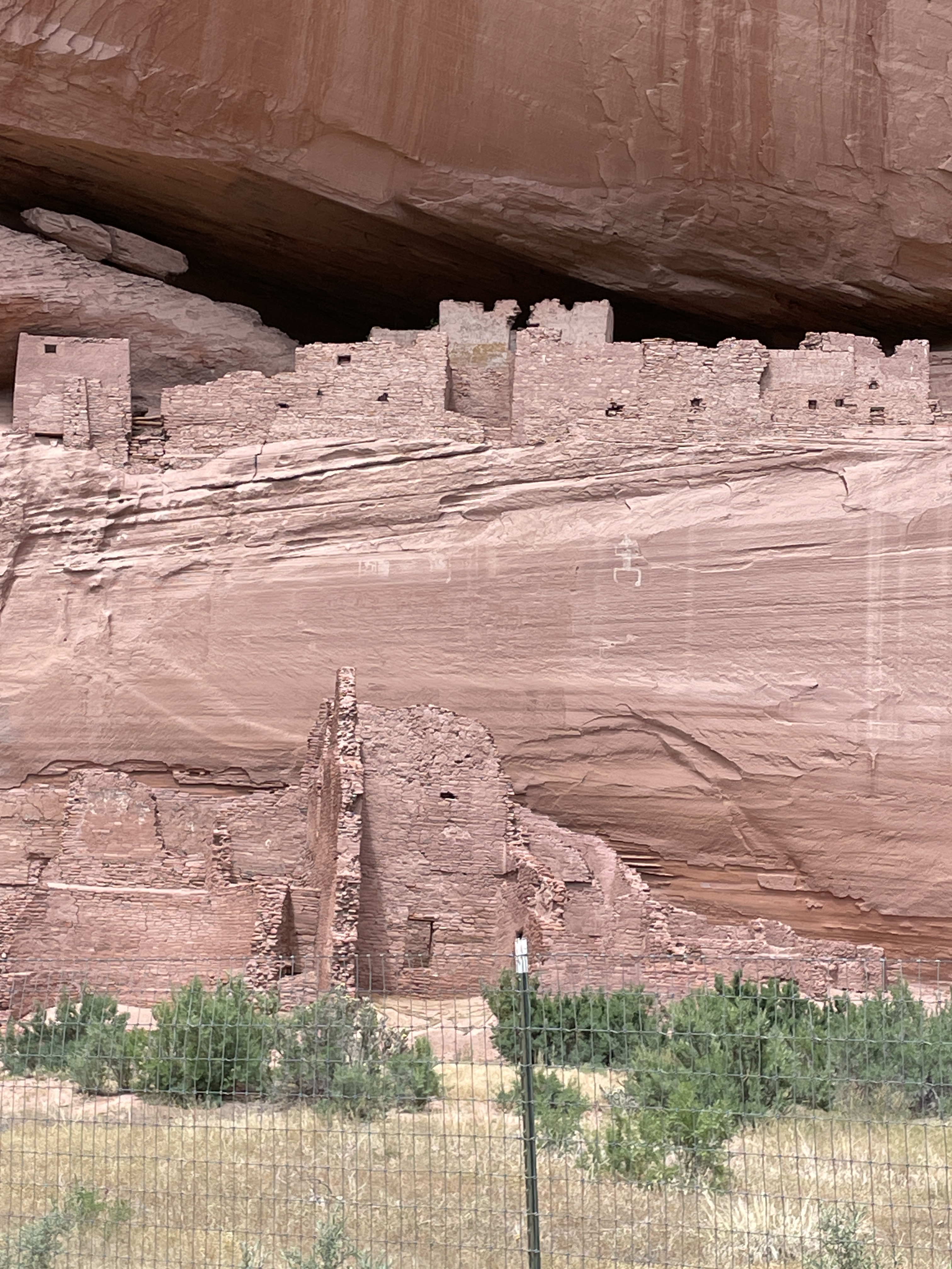
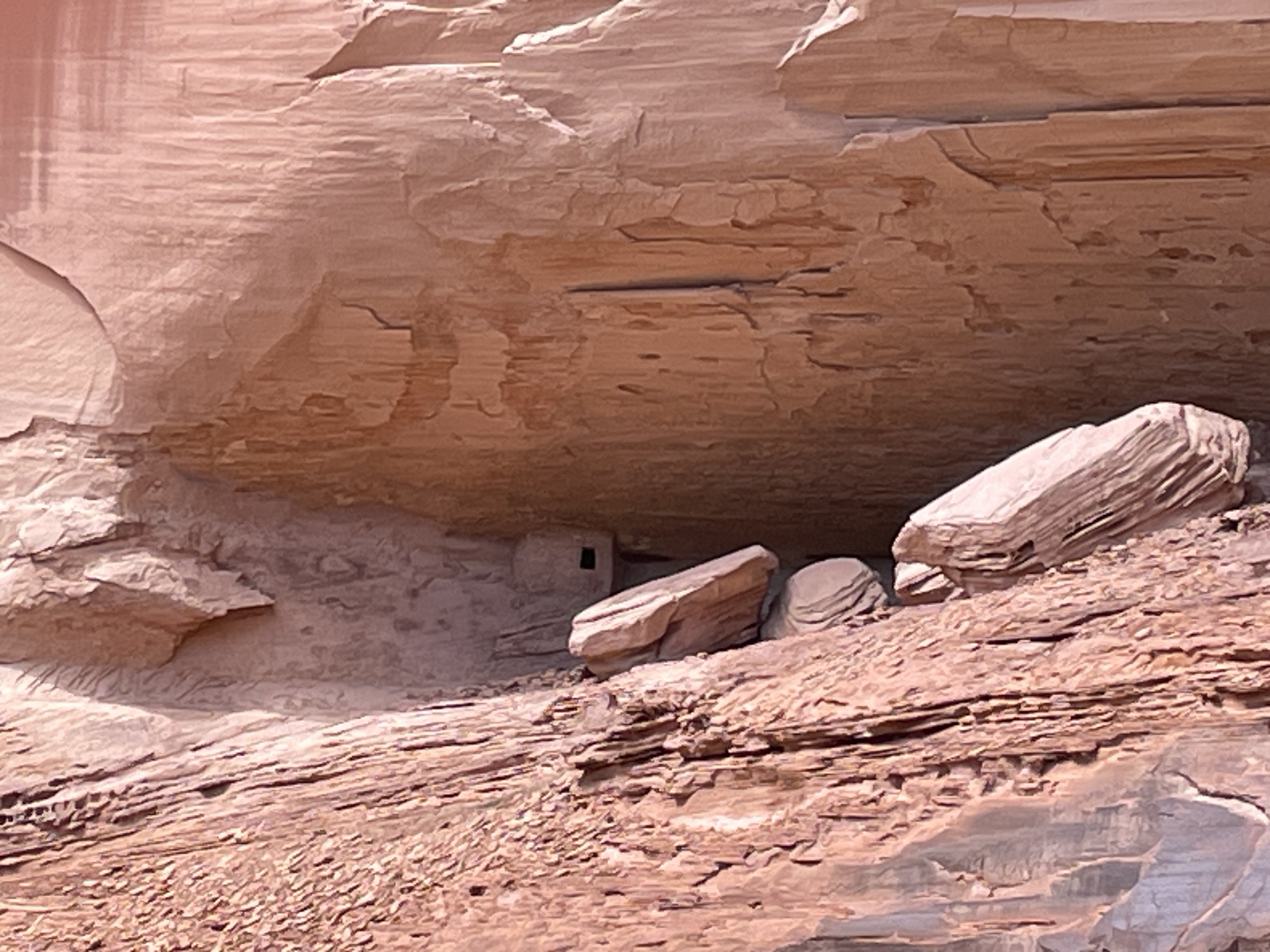
Ancient pueblo people lived here for centuries, some more than 5,000 years ago. This is one of the largest pueblo structures in the canyon (The White House–due to a white washed wall which you cannot see from this vantage point). The fence was built to protect it from vandals. We saw many smaller dwelling places and Oscar said there are hundreds in the canyon.
Headed back down the wash. This was a half day trip so only saw less than half of the canyon. You can hire for an all day trip complete with picnic lunch and go all the way to some of the famous formations that can be seen from the road at the edge of the top. There is also a side canyon called Muerto–due to a massacre of the natives that occurred after the Navaho forced long march.
The Jeep needs a bath after this trip.
Note: With a permit and guides, there is camping and horseback riding trips up the canyon in addition to this type of tour.
One of the most famous canyons in the country resides inside the Dine (Navaho) Nation. While administered by the National Park service, it is also the home of several Dine families. You can drive through the roads on the top freely, stop at various viewpoints, take photos, etc. Here are the various views I saw last week while there. The bottom of the canyon is restricted. To go there, you need a permit and a Dine (Navaho) guide. More about that in the next post.
Several families live in the bottom of the canyon, especially during the summer months. You cannot go into the bottom of the canyon without a permit and a Navaho guide.